



Bay-Delta Watershed
The San Francisco Bay/Sacramento-San Joaquin Delta (Bay-Delta) watershed is the hub of California’s water supply system, a winding, interconnected network of channels, islands and wetlands formed by the convergence of the Sacramento and San Joaquin Rivers. Spanning roughly 1,100 square miles, the Bay-Delta is one of the largest tidal estuaries on the West Coast of the Americas.
An ecological treasure, the Bay-Delta provides habitat for more than 750 animal and plant species, including salmon and other native fish. The Bay-Delta watershed is significantly important to numerous Native American Tribes whose way of life, culture, religion, and sustenance are intricately interwoven and interdependent.
The Sacramento and San Joaquin Rivers and their tributaries provide drinking water to almost 30 million residents and serve the nation’s leading agricultural industry. The water is conveyed primarily through two delivery projects – the State Water Project and Central Valley Project – that pump and export freshwater from the Delta each year to cities, businesses and farms in the Central Valley, San Francisco Bay Area, and Southern California.
Protecting water quality in the Bay-Delta is a key responsibility and top priority for the State Water Board.
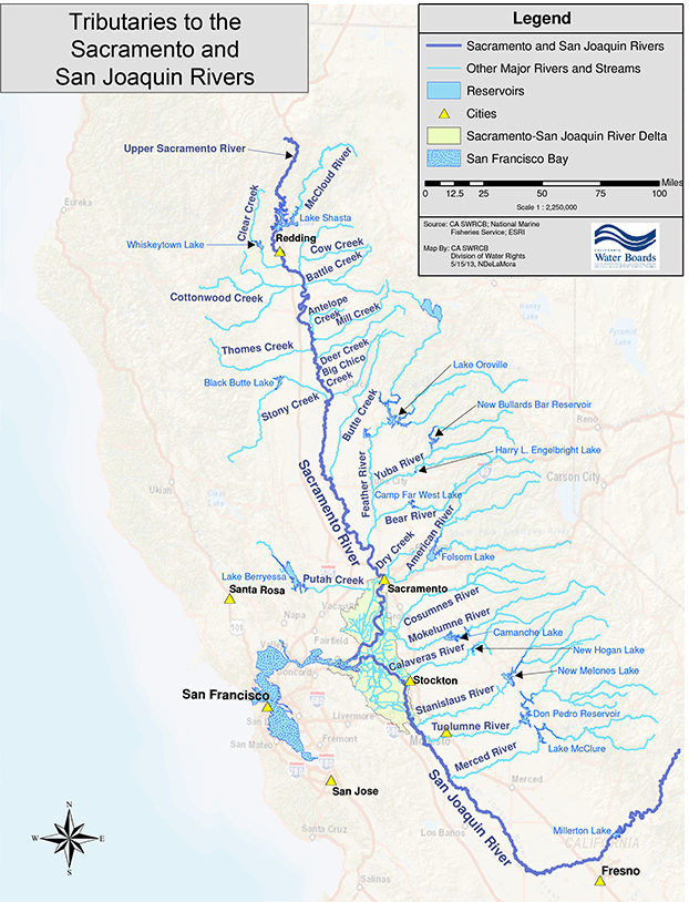
Bay-Delta (select map to enlarge)
Bay-Delta System
Announcements
Sacramento/Delta Update to the Bay-Delta Plan
On August 19, 2026, the State Water Board released the following for public review:
- Final draft Bay-Delta Plan
- Final Staff Report, including written responses to previously submitted comments
- Final Scientific Basis Report Supplement in support of Voluntary Agreements (also referred to as the Healthy Rivers and Landscapes proposal)
Written comments on the final draft Bay-Delta Plan are due on September 18, 2026. The State Water Board will consider adoption of the final draft Plan and final Staff Report at a public meeting on October 28-29, 2026. See the notice (aviso en Español) and Sacramento/Delta update webpage for additional information.
Bay-Delta Plan
The State Water Board protects the watershed primarily through the Bay-Delta Water Quality Control Plan. The Plan’s goal is to protect the Bay-Delta’s natural ecosystems and its beneficial uses, including municipal, agricultural, recreational, fish and wildlife, and others. The State Water Board is currently working toward incorporating Tribal Beneficial Uses in the Plan.
The Plan is required to be reviewed periodically and updated as needed to provide for the reasonable protection of the Bay Delta watershed's beneficial uses. The review, development, and adoption of water quality and flow objectives require public participation, and must comply with the California Environmental Quality Act, Porter-Cologne Water Quality Control Act, and other laws.
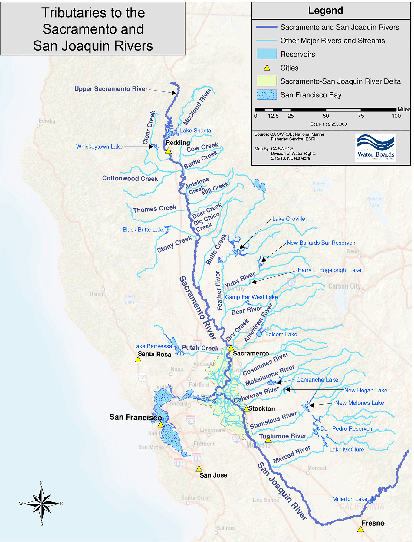
Two vast and distinct river systems join to form the Bay-Delta—the Sacramento River in the north and the San Joaquin River in the south. Each of these systems is fed by snowmelt from different geographic regions that vary significantly in terms of hydrology, topography, precipitation patterns, and at-risk native fish and wildlife. For this reason, the Bay-Delta Plan is being updated and implemented through separate processes.
Additional information about the Bay-Delta Plan can be found on the pages linked below and our FAQs.
Recent Bay-Delta Actions
- January 28-30, 2026 – Public Hearing on Revised Draft Sacramento/Delta Updates to Bay-Delta Plan and Chapter 13 of Supporting Draft Staff Report
- November 5, 2025 – Workshop on the Draft Scientific Basis Report Supplement for the Tuolumne River Voluntary Agreement Proposal
- Staff Presentation
- Public Presentations (Available on Request)
- California Sportfishing Protection Alliance
- Golden State Salmon Association
- Friends of the River and San Francisco Baykeeper
- Turlock Irrigation District, Modesto Irrigation District, and San Francisco Public Utilities Commission 1 | 2
- Yosemite Rivers Alliance
Outreach and Engagement
Water Rights Fact Sheets
- April 2024 – Water Rights 101
- April 2024 – Water Use Reporting Requirements
Environmental Justice
- June 7, 2023 – Environmental Justice Focused Listening Session
- March 27, 2023 – Environmental Justice Focused Listening Session
Bay-Delta Tribal Coordination
- August 25, 2025 – SECOND REVISED Notice to Tribes of Revised Draft Sacramento/Delta/Updates to the Bay-Delta Plan
- August 15, 2025 – REVISED Notice to Tribes of Revised Draft Sacramento/Delta/Updates to the Bay-Delta Plan
- July 24, 2025 – Notice to Tribes of Revised Draft Sacramento/Delta Updates to the Bay-Delta Plan
- November 1, 2024 – REVISED Notice to Tribes of Draft Sacramento/Delta Updates to the Bay-Delta Plan
- October 25, 2024 – Notice to Tribes of Draft Sacramento/Delta Updates to the Bay-Delta Plan
- November 9, 2023 – Tribal Workshop on Sacramento/Delta Draft Staff Report
- June 7, 2023 – Board Meeting Informational Item on Addition of Tribal Beneficial Uses to Bay-Delta Plan
- May 4, 2023 – Tribal Listening Session
Visit our tribal coordination webpage for more information on outreach and consultation with California Native American Tribes.
Mill, Deer, and Antelope Creeks
- November 7, 2024 – Notice of Opportunity for Preliminary Public Comment and Notice of Public Workshop on the Scope of a Scientific Basis Report for Mill, Deer, and Antelope Creeks (Spanish)
- February 21, 2024 – Revised Letter from California Department of Fish and Wildlife Submitting Instream Flow Recommendations)
- Flow Recommendations Main Webpage
Additional Resources
Water Quality Control Plans and Associated Water Right Decisions
Bay-Delta Compliance
Drought
- Sacramento-San Joaquin Delta Watershed Drought
- Merced River Conditions in 2022
- Water Unavailability Methodology for the Delta Watershed
- Temporary Urgency Change Petitions
Other
Stay informed
Email Subscription List
Subscribe to the Bay Delta Notices email topic to receive notifications and the latest updates.
Contact Us
Lower San Joaquin River/Southern Delta: LSJR-SD-Comments@waterboards.ca.gov
Sacramento/Delta: SacDeltaComments@waterboards.ca.gov
Other Bay-Delta matters: Bay-Delta@waterboards.ca.gov

