
Supply and Demand Assessment (SDA) – Pismo and San Luis Obispo Creeks Watershed
Overview
The Pismo and San Luis Obispo Creeks watershed covers approximately 122.5 square miles in San Luis Obispo County. The watershed includes three main streams: Upper San Luis Obispo Creek, Lower San Luis Obispo Creek, and Pismo Creek. These creeks originate in the Santa Lucia Mountains and drain westward to the Pacific Ocean near Avila Beach and Pismo Beach, respectively. Major tributaries include West and East Corral de Piedra Creeks, Cañada Verde, and Cuevitas Creek. The watershed ranges in elevation from sea level to over 2,700 feet and has a Mediterranean climate with wet winters and dry summers. Average annual precipitation is approximately 24 inches, mostly falling between November and March. The land cover is primarily shrubland, grassland, and mixed forest, with developed areas concentrated in the cities of San Luis Obispo, Pismo Beach, and surrounding communities.
Pismo Creek provides important habitat for federally threatened steelhead trout (Oncorhynchus mykiss), which rely on seasonal streamflow for upstream migration and juvenile outmigration. However, low summer baseflows, habitat fragmentation, and sedimentation impair habitat quality. The creek is listed as impaired under Section 303(d) of the Clean Water Act for multiple pollutants including pathogens, nutrients, metals, chloride, and sodium.
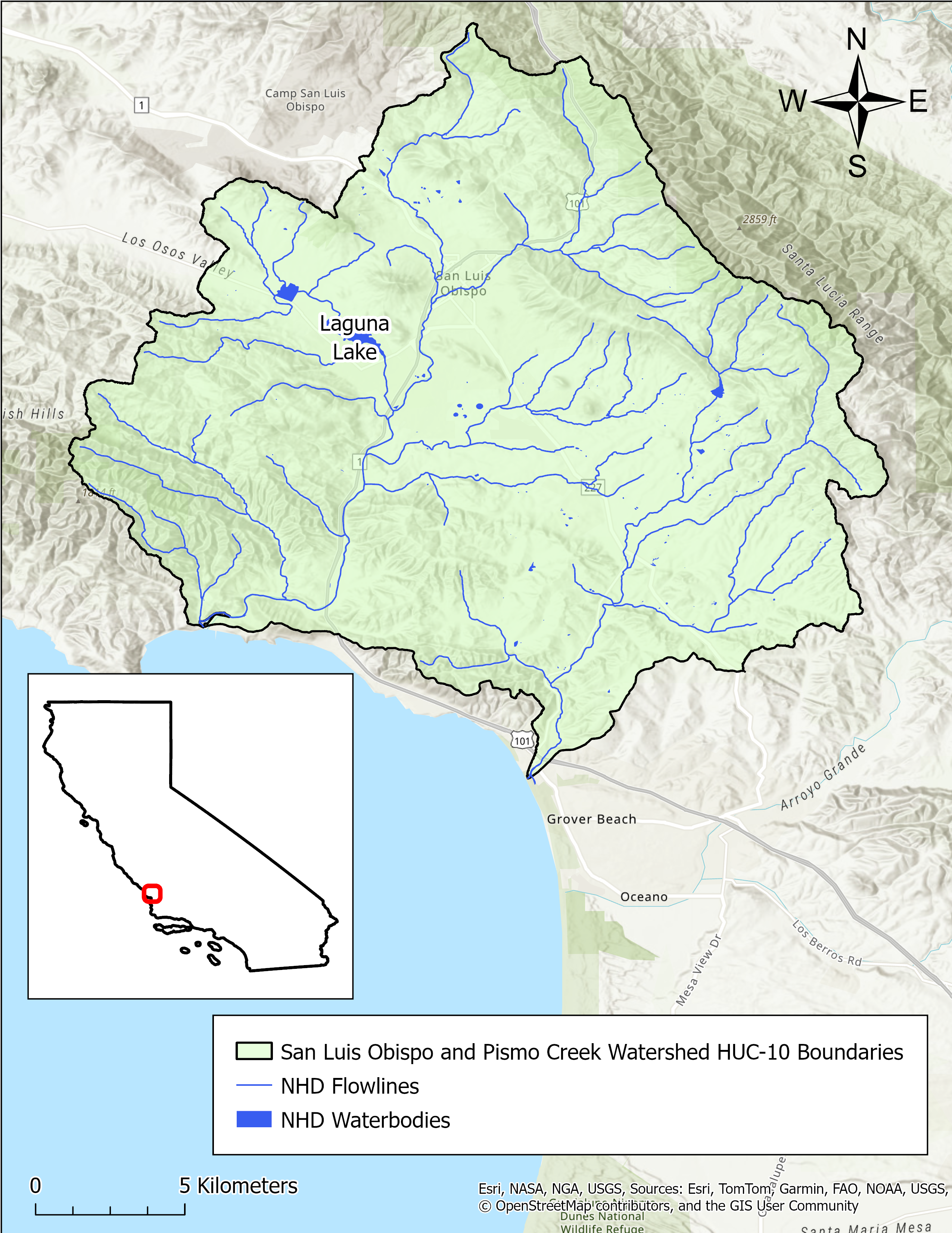
- Click on Map to Enlarge
Announcements
May 29, 2026 - Pismo and San Luis Obispo Creeks Watershed Model Work Plan - Now Available
The work plan from Paradigm Environmental for development of a hydrologic model for the Pismo and San Luis Obispo Creeks watershed is now publicly available in Model Development section below. Please email questions regarding the model development to DWR-SDA@waterboards.ca.gov.
Model Development
Outreach and Engagement
- Pismo and San Luis Obispo Creeks Watershed Fact Sheet – Coming Soon
Modeling in the Pismo and San Luis Obispo Creeks Watershed
The SDA Unit has continued to work on the models and tools developed for the Russian River Watershed during the State Water Board's 2021-2022 Regional Drought Response. These tools provided the necessary information for the Division of Water Rights (Division) to assess water availability and issue water right curtailments to ensure adequate, minimal water supplies for critical purposes under the emergency regulation.
To capture the water demand in the SDA Program Watersheds, water right demand estimates were incorporated based on information from annual reports of water diversion and use submitted to the Division. The SDA Unit continued to develop the Division's demand dataset methodology and converted it into a series of R scripts and manual review spreadsheets that apply data quality correction flags. For example, the scripts identified and corrected unit conversion errors, duplicate reporting, and misplotted points of diversion. The SDA Unit then uses a water allocation tool adopted from the UC Davis Drought Water Rights Allocation Tool (DWRAT) to allocate available supply amongst water right holders based on their respective water right priority and water demands. This version of DWRAT allocates water at the subbasin level and accounts for imported flows.
The SDA Unit's demand methodology, along with the supply scripts and the watershed specific versions of DWRAT, will be made available on the California Water Board Data Center GitHub page as separate repositories.
Supply and Demand Assessment Program Links
Supply and Demand Assessment Information
Project Watersheds:
Stay Informed
Email Subscription List
Subscribe to the SDA Information email topic to receive notifications and the latest updates.
Contact Us
If you have questions or please email them to: DWR-SDA@waterboards.ca.gov
